|
CANADIAN ARCTIC 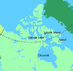
The photographs of Iqaluit, Igloolik, and Sarcpa Lake, Nunavut, were taken during a York University High Arctic field course, July 20 to August 21, 1977.  We flew from Montreal to Iqaluit (Frobisher Bay) on Baffin Island, then to Igloolik, a small Inuit settlement on Igloolik Island above the Arctic Circle. One week later, we flew to Sarcpa Lake, an abandoned USAF DEW line station on the Melville Peninsula. The runway had been used since the station was deserted in 1963 to provide an emergency landing site in case of fog and other bad weather. Our purpose was to clean up and repair the main building and a small house to serve as an Arctic scientific research station.
I made two visits to do research at the Churchill Northern Studies Centre, 20 km east of Churchill, Manitoba. The photographs were taken at the end of April, 1996, during the second trip.
We flew from Montreal to Iqaluit (Frobisher Bay) on Baffin Island, then to Igloolik, a small Inuit settlement on Igloolik Island above the Arctic Circle. One week later, we flew to Sarcpa Lake, an abandoned USAF DEW line station on the Melville Peninsula. The runway had been used since the station was deserted in 1963 to provide an emergency landing site in case of fog and other bad weather. Our purpose was to clean up and repair the main building and a small house to serve as an Arctic scientific research station.
I made two visits to do research at the Churchill Northern Studies Centre, 20 km east of Churchill, Manitoba. The photographs were taken at the end of April, 1996, during the second trip. |